Tracing where the Zambezi River lies in Africa’s safari map
Understanding where the Zambezi River in Africa lies is essential for planning meaningful safari and wildlife adventures. This great river in southern Africa rises as a modest marshy source in remote northwestern Zambia, close to the border with Angola, then begins a long journey that shapes landscapes and ecosystems. From the outset, the young river threads through miombo woodland, where small streams merge into the emerging upper Zambezi.
Geographically, the Zambezi River is the fourth longest river Africa offers, running about 3 540 kilometres across southern Africa. It flows from zambia angola borderlands through Namibia’s Caprivi Strip, briefly touching Botswana, then forming the frontier of zambia zimbabwe before crossing Mozambique to the Indian Ocean. Along this route, the river flows through distinct regions known as the upper Zambezi, middle Zambezi, and lower Zambezi, each with different safari opportunities.
For travellers asking where is the Zambezi River in Africa, the answer is inseparable from wildlife. The upper reaches support floodplains that attract antelope, birds, and traditional fishing communities dependent on seasonal water. Further downstream, the middle Zambezi carves dramatic gorges and feeds vast lake systems, while the lower Zambezi nourishes fertile valleys and the extensive zambezi delta. Together, these regions create a continuous corridor of habitats that sustain elephants, predators, and countless smaller species.
As the river progresses, it also becomes a vital engine for hydroelectric power and irrigation, supporting communities across southern Africa. Yet for safari enthusiasts, its greatest value lies in the wild character of its banks, islands, and adjoining national park areas. Understanding this geography helps you choose where along the Zambezi River your own journey should begin.
From source to Victoria Falls : mapping the upper and middle Zambezi
The story of where the Zambezi River in Africa begins starts in a quiet, boggy source area in northwestern Zambia. Here, the young river flows gently through rural landscapes, shared by subsistence farmers and traditional fishers who rely on its seasonal rhythms. This region, part of the upper Zambezi, remains relatively undeveloped and offers limited formal safari infrastructure, yet it is crucial for the health of downstream ecosystems.
As the river leaves its source, it crosses into Angola, then swings back toward Zambia and Namibia, broadening into floodplains that teem with birdlife during the rainy season. These upper stretches of the Zambezi River are defined by slow channels, papyrus beds, and seasonal lagoons, where the river flows lazily but steadily. Canoe excursions and community based tourism projects here offer a quieter alternative to the dramatic falls further downstream.
Approaching the border of zambia zimbabwe, the river narrows and accelerates before plunging over the basalt lip of Victoria Falls. This is where the question “where is the Zambezi River in Africa” becomes tangible, as the water roars into the chasm known as Batoka Gorge. “Visit Victoria Falls, one of the world's largest waterfalls.” The surrounding Victoria Falls town on the Zimbabwe side and Livingstone on the Zambia side serve as major hubs for adventure activities.
Below the falls, the middle Zambezi cuts through the steep Batoka Gorge, creating world class white water rafting and scenic flights that reveal the river’s power. This section also marks the transition toward major dams that harness hydroelectric power. For broader context on predator dynamics in the region’s protected areas, analyses such as this piece on how unchecked hyena populations reshape Kruger Park help travellers understand how large ecosystems interconnect across southern Africa.
Kariba, Cahora Bassa and the great lakes of the Zambezi basin
Downstream from Victoria Falls, the question of where the Zambezi River in Africa flows next leads to some of the continent’s most significant artificial lake systems. The first is Lake Kariba, created by the monumental Kariba Dam on the border of zambia zimbabwe. This vast lake stretches for hundreds of kilometres, forming a crucial reservoir for hydroelectric power and a thriving habitat for fish, crocodiles, and hippos.
The Kariba Dam transformed a wild river gorge into a watery expanse that now supports houseboat safaris and shoreline lodges. On both the Zambia and Zimbabwe sides, protected areas and informal reserves host elephants, lions, and abundant birdlife that come to drink from the water. The broader lake kariba region illustrates how rivers in southern Africa can be both engineered for energy and preserved for wildlife tourism.
Further downstream in Mozambique, the Cahora Bassa project created another immense lake behind the Cahora Bassa dam. Here, the middle Zambezi widens again, and the river flows through rugged hills that remain relatively little visited by international safari travellers. “Development of new hydroelectric projects.” These large reservoirs, including Kariba and Cahora Bassa, are central to regional power grids and cross border energy trade.
For wildlife enthusiasts, the shorelines of lake kariba and Cahora Bassa offer opportunities to see elephants swimming between islands and predators patrolling the fringes. When planning where to experience the Zambezi River in Africa, consider combining lake based safaris with classic game drives in renowned reserves such as Kruger, whose wildlife dynamics are explored in depth in this guide to Kruger National Park animals on safari. Together, these destinations reveal how interconnected rivers, dams, and parks are across the region.
Lower Zambezi and national parks : prime safari landscapes
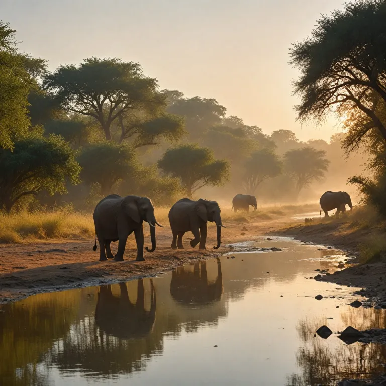
As the river leaves the great reservoirs behind, it enters the celebrated lower Zambezi valley, one of the finest safari regions in southern Africa. Here, the river flows broad and deep between escarpment hills, creating fertile floodplains and islands that attract dense concentrations of wildlife. The water level fluctuates with the rainy season, shaping grazing patterns and predator movements.
On the Zambia side, Lower Zambezi National Park protects a mosaic of woodland, channels, and sandbanks where elephants wade chest deep and buffalo gather in large herds. Opposite, on the Zimbabwe bank, Zambezi National Park and other protected areas continue the conservation corridor. Together, these national park landscapes make the lower Zambezi River a premier answer to where the Zambezi River in Africa offers the most immersive wildlife experiences.
Game viewing here often happens from boats and canoes, giving a low angle perspective on hippos, crocodiles, and drinking antelope. Anglers target tigerfish in the main river channels, while birders scan the riverside forests for kingfishers and African fish eagles. During the rainy season, some floodplain tracks become inaccessible, but the landscape turns lush, and the water based safaris remain exceptional.
Understanding predator behaviour along the lower Zambezi can be enriched by reading field based analyses such as this article on expert insights into tracking leopards in the wild. These insights complement on the ground experiences in national park concessions, where guides interpret tracks on the river banks each morning. For many travellers, this valley becomes the emotional heart of their understanding of where the Zambezi River in Africa truly comes alive.
The Zambezi delta and journey to the Indian Ocean
Beyond the famed safari heartlands, the river continues its journey through Mozambique toward the sea, forming the extensive Zambezi delta. Here, the lower Zambezi splits into multiple channels and rivers that weave through mangroves, floodplains, and coastal wetlands. This region is crucial for fisheries, birdlife, and local communities who depend on the water for transport and livelihoods.
As the river flows across the coastal plain, it carries sediments from Zambia, Zimbabwe, and Angola, gradually building new land in the Zambezi delta. During the rainy season, floodwaters spread across wide areas, replenishing soils and sustaining agriculture. The delta’s ecological health is closely linked to upstream management of Kariba Dam, Cahora Bassa, and other hydroelectric power projects that regulate seasonal flows.
Finally, the Zambezi River empties into the warm Indian Ocean on the coast of Mozambique, completing the long path that began at its modest source in Zambia. For travellers tracing where the Zambezi River in Africa ends, this coastal region offers a different kind of wilderness, with mangrove forests, offshore marine life, and cultural encounters in riverine towns. While less developed for classic big game safaris, it is rich in birding, boating, and photographic opportunities.
Understanding this full journey from upper Zambezi to Zambezi delta helps travellers appreciate how interconnected the system is. “The Zambezi River flows through Zambia, Angola, Namibia, Botswana, Zimbabwe, and Mozambique.” When you stand on a sandbank in the lower Zambezi or gaze across lake kariba, you are part of a basin that stretches all the way to the ocean. This perspective encourages more responsible choices about where and how to travel along the river Africa offers here.
Planning safaris along the Zambezi : seasons, activities and conservation
When deciding where along the Zambezi River in Africa to focus your safari, seasonality is a crucial factor. The rainy season typically brings higher water levels, greener landscapes, and more challenging road access in some national park areas. In contrast, the drier months concentrate wildlife along the river and its channels, making sightings more predictable.
In the upper Zambezi, seasonal floodplains are best explored when the water is high enough for canoeing but not yet at peak flood. Around Victoria Falls, the volume of water over the falls changes dramatically through the year, influencing visibility and the intensity of spray. “Visit Victoria Falls, one of the world's largest waterfalls.” This variability means that travellers should match their expectations, whether they prioritise dramatic falls views, rafting in Batoka Gorge, or calmer photographic conditions.
Further downstream, in Lower Zambezi National Park and Zambezi National Park, dry season months are ideal for boat based game viewing and walking safaris. Houseboat trips on lake kariba or fishing excursions on Cahora Bassa lake offer slower paced experiences that still keep you close to the river’s wildlife. “Explore the diverse wildlife along the river.”
Responsible travel choices also support conservation across the zambezi basin, where pressures from development, hydroelectric power expansion, and climate change are significant. “Engage in activities such as white-water rafting and fishing.” By choosing operators who respect park regulations, support local communities, and minimise impacts on rivers and floodplains, you help safeguard the future of this remarkable southern Africa waterway. In doing so, you deepen your understanding of where the Zambezi River in Africa fits within broader regional sustainability efforts.
Key statistics about the Zambezi River
- Length of the Zambezi River : 3 540 kilometres.
- Drainage area of the Zambezi River : 1 300 000 square kilometres.
Essential questions about the Zambezi River and safaris
What countries does the Zambezi River flow through ?
The Zambezi River flows through Zambia, Angola, Namibia, Botswana, Zimbabwe, and Mozambique. For safari travellers, the most visited stretches are generally in zambia zimbabwe around Victoria Falls, lake kariba, and the lower Zambezi valley. However, the full basin extends across much of southern Africa, influencing ecosystems far beyond the immediate river banks.
What is the significance of Victoria Falls ?
Victoria Falls is one of the world's largest and most famous waterfalls, located on the Zambezi River at the border between Zambia and Zimbabwe. For visitors exploring where the Zambezi River in Africa offers its most dramatic scenery, this is often the first stop. The falls also act as a gateway to broader safari circuits that include national park areas upstream and downstream.
How is the Zambezi River utilized ?
The river is used for hydroelectric power generation, agriculture, fishing, and tourism. Major structures such as Kariba Dam and Cahora Bassa dam supply electricity across borders, while floodplains support crops and grazing. For safari travellers, understanding these multiple uses adds depth to journeys along the Zambezi River, from upper Zambezi wetlands to the Zambezi delta on the Indian Ocean coast.
